
Your All-in-One Scanning Solution
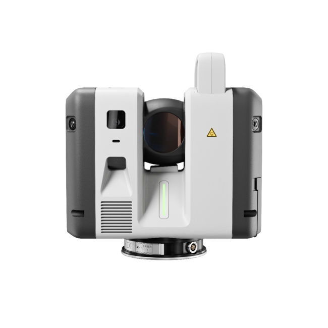
Innovation and excellence combine in the RTC360, making it an industry leading, powerhouse of a scanner in a small package. Get superior results and superior portability with one unit.
Terrestrial Reality Capture
Looking for an RTC360? We have limited remaining stock. Contact us.
Portability, precision, and speed in one beautifully compact package from Leica Geosystems.
The RTC360 from Leica Geosystems is an amazing scanner that combines portability, precision, and speed in a beautiful compact package.
Jam-packed with powerful features to help you gather measurements with precision, ease, and speed, the RTC360 is a key tool in dominating your competition and maximizing your productivity. Check out this video that highlights the technical features that make the RTC360 such an astounding and innovative tool.
The RTC360 empowers users to document and capture their environments in 3D, improving efficiency and productivity in the field with speed, ease-of-use, and portability even on the most complex of projects.
No matter what you need to scan, the RTC360 can get you reliable data in less time than ever before. Small and lightweight, the Leica RTC360 scanner’s portable design and collapsible tripod mean it’s compact enough to fit into most backpacks, ready to be taken anywhere. Once on-site, easy-to-use, one-button operation makes for fast, hassle-free scanning.
Check out everything included in the box when you purchase an RTC360. With this amazing little scanner, you can be up and running to maximize your productivity in no time flat.
Innovation and excellence combine in the RTC360, making it an industry leading, powerhouse of a scanner in a small package. Get superior results and superior portability with one unit.

With a measuring rate of up to 2 million points per second and advanced HDR imaging system, the creation of coloured 3D point clouds can be completed in under two minutes.

Automated targetless field registration and the seamless, automated transfer of data from site to office reduce time spent in the field and further maximise productivity.
When documenting the scene of accident, police can capture accurate mapping of crash and collisions at record speed with the RTC360. Limit interruptions to traffic and infrastructure by using advanced laser scanning technology that allows officers to quickly document millions of measurements for further investigation and evaluation from the office. Keep officers safely out of traffic by gathering data from a safe distance with the RTC360.
From archeological digs to historical restoration work, accurate replicas of existing conditions are key to achieving high quality results, with lasting effects for generations to come. The RTC360 is a non-invasive way to document site conditions, collect measurements, and gather data for generations to come.
From planning to building to BIM, Leica's RTC360 enables construction professionals to manage every step of their project with precision, speed, and accuracy. The RTC360 makes on site scanning faster and safer than ever before, and the pre-registration of point clouds in the field saves you immense time back at your office as you work with the data you've collected on site.
Survey professionals have impeccably high standards. The RTC360 can help you to deliver amazing results to your clients in record time.

Tell us when suits you and one of our experts will reach out to set up a demo.
Trusted by companies across Canada and the United States.
“R-E-A-L.iT’s assistance in helping RH Borden to get the most out of reality capture technology for our business has helped us deliver exceptional results for our clients. The custom software script that R-E-A-L.iT’s team created for us is enabling us to get high-quality deliverables into the hands of our clients in record time.”

“R-E-A-L.iT has been our dedicated source for all Leica Geosystems products for some time and we couldn’t be happier than with the service we’ve received. Their team shows passionate product knowledge and a handle on the latest in the industry. Derek has always been quick, courteous and very helpful. We will continue to purchase and rent Leica Geosystems 3D laser scanners with R-E-A-L.iT.”

“We’ve really enjoyed working with R-E-A-L.iT — renting reality capture gear through your team has been a smooth, reliable experience that helps us stay agile and efficient on our projects. The equipment is top-notch, and your service makes it easy to focus on the work at hand.”

“Unlike with some sales experiences, Derek and his team have been constantly available to us both pre- and post-sale, partnering with TELUS in implementing complex and long-term applications of reality capture solutions to our business.”
Trusted by companies across Canada and the United States.
“R-E-A-L.iT’s assistance in helping RH Borden to get the most out of reality capture technology for our business has helped us deliver exceptional results for our clients. The custom software script that R-E-A-L.iT’s team created for us is enabling us to get high-quality deliverables into the hands of our clients in record time.”
“R-E-A-L.iT has been our dedicated source for all Leica Geosystems products for some time and we couldn’t be happier than with the service we’ve received. Their team shows passionate product knowledge and a handle on the latest in the industry. Derek has always been quick, courteous and very helpful. We will continue to purchase and rent Leica Geosystems 3D laser scanners with R-E-A-L.iT.”
“We’ve really enjoyed working with R-E-A-L.iT — renting reality capture gear through your team has been a smooth, reliable experience that helps us stay agile and efficient on our projects. The equipment is top-notch, and your service makes it easy to focus on the work at hand.”
“Unlike with some sales experiences, Derek and his team have been constantly available to us both pre- and post-sale, partnering with TELUS in implementing complex and long-term applications of reality capture solutions to our business.”
Contact us now for more information or to get started on your reality capture journey.
