
La Sua soluzione di scansione all-in-one
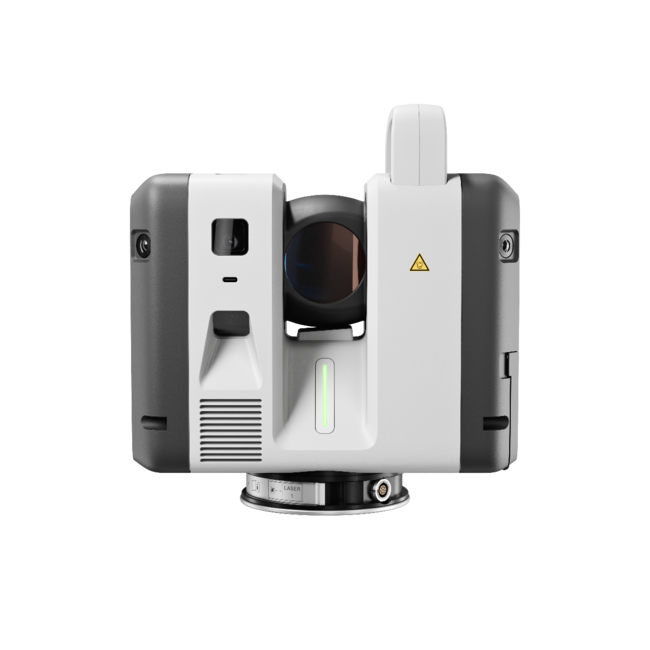
Innovation and excellence combine in the RTC360, making it an industry leading, powerhouse of a scanner in a small package. Get superior results and superior portability with one unit.
Reality capture terrestre
Looking for an RTC360? We have limited remaining stock. Ci contatti.
Portabilità, precisione e velocità in un formato compatto ed elegante firmato Leica Geosystems.
L’RTC360 di Leica Geosystems è uno scanner straordinario che unisce portabilità, precisione e velocità in un formato compatto ed elegante.
Ricco di funzioni avanzate per acquisire misure con precisione, semplicità e rapidità, l’RTC360 è uno strumento chiave per superare la concorrenza e massimizzare la produttività. Guardi questo video che illustra le caratteristiche tecniche che rendono l’RTC360 uno strumento così sorprendente e innovativo.
L’RTC360 consente di documentare e acquisire gli ambienti in 3D, migliorando efficienza e produttività sul campo grazie a rapidità, facilità d’uso e portabilità, anche nei progetti più complessi.
Qualunque cosa debba scansionare, l’RTC360 Le fornisce dati affidabili in meno tempo che mai. Piccolo e leggero, grazie al design portatile e al treppiede pieghevole lo scanner Leica RTC360 entra nella maggior parte degli zaini ed è pronto per essere portato ovunque. In cantiere, il funzionamento semplice con un solo pulsante garantisce scansioni rapide e senza complicazioni.
Check out everything included in the box when you purchase an RTC360. With this amazing little scanner, you can be up and running to maximize your productivity in no time flat.
Innovation and excellence combine in the RTC360, making it an industry leading, powerhouse of a scanner in a small package. Get superior results and superior portability with one unit.

Con una velocità di misura fino a 2 milioni di punti al secondo e un avanzato sistema di imaging HDR, una nuvola di punti 3D a colori si ottiene in meno di due minuti.

La registrazione automatica sul campo senza target e il trasferimento automatico e continuo dei dati dal cantiere all’ufficio riducono il tempo sul campo e aumentano ulteriormente la produttività.
Nel rilievo della scena di un incidente, con l’RTC360 le forze dell’ordine possono mappare con precisione sinistri e collisioni in tempi record. La tecnologia di scansione laser avanzata riduce le interruzioni al traffico e alle infrastrutture, consentendo agli agenti di registrare rapidamente milioni di misure da analizzare e valutare in seguito in ufficio. Con l’RTC360 gli agenti acquisiscono i dati a distanza di sicurezza, lontano dal traffico.
Dagli scavi archeologici al restauro di beni storici, repliche accurate dello stato di fatto sono fondamentali per risultati di qualità, destinati a durare per le generazioni future. L’RTC360 permette di documentare il sito, rilevare misure e raccogliere dati in modo non invasivo.
Dalla pianificazione alla costruzione fino al BIM, il Leica RTC360 consente ai professionisti dell’edilizia di gestire ogni fase del progetto con precisione e rapidità. Rende la scansione in cantiere più veloce e sicura che mai, e la pre-registrazione delle nuvole di punti sul campo fa risparmiare moltissimo tempo in ufficio durante l’elaborazione dei dati acquisiti.
I professionisti del rilievo hanno standard altissimi. L’RTC360 La aiuta a consegnare ai clienti risultati straordinari in tempi record.

Tell us when suits you and one of our experts will reach out to set up a demo.
Trusted by companies across Canada and the United States.
“R-E-A-L.iT’s assistance in helping RH Borden to get the most out of reality capture technology for our business has helped us deliver exceptional results for our clients. The custom software script that R-E-A-L.iT’s team created for us is enabling us to get high-quality deliverables into the hands of our clients in record time.”

“R-E-A-L.iT has been our dedicated source for all Leica Geosystems products for some time and we couldn’t be happier than with the service we’ve received. Their team shows passionate product knowledge and a handle on the latest in the industry. Derek has always been quick, courteous and very helpful. We will continue to purchase and rent Leica Geosystems 3D laser scanners with R-E-A-L.iT.”

“We’ve really enjoyed working with R-E-A-L.iT — renting reality capture gear through your team has been a smooth, reliable experience that helps us stay agile and efficient on our projects. The equipment is top-notch, and your service makes it easy to focus on the work at hand.”

“Unlike with some sales experiences, Derek and his team have been constantly available to us both pre- and post-sale, partnering with TELUS in implementing complex and long-term applications of reality capture solutions to our business.”
Trusted by companies across Canada and the United States.
“R-E-A-L.iT’s assistance in helping RH Borden to get the most out of reality capture technology for our business has helped us deliver exceptional results for our clients. The custom software script that R-E-A-L.iT’s team created for us is enabling us to get high-quality deliverables into the hands of our clients in record time.”
“R-E-A-L.iT has been our dedicated source for all Leica Geosystems products for some time and we couldn’t be happier than with the service we’ve received. Their team shows passionate product knowledge and a handle on the latest in the industry. Derek has always been quick, courteous and very helpful. We will continue to purchase and rent Leica Geosystems 3D laser scanners with R-E-A-L.iT.”
“We’ve really enjoyed working with R-E-A-L.iT — renting reality capture gear through your team has been a smooth, reliable experience that helps us stay agile and efficient on our projects. The equipment is top-notch, and your service makes it easy to focus on the work at hand.”
“Unlike with some sales experiences, Derek and his team have been constantly available to us both pre- and post-sale, partnering with TELUS in implementing complex and long-term applications of reality capture solutions to our business.”
Contact us now for more information or to get started on your reality capture journey.
