
Sensor Fusion
The BLK2GO uses real-time LiDAR scanning and SLAM tracking for mobile mapping of 3D spaces.
The BLK2GO from Leica Geosystems is the fastest and easiest way to scan any large space or structure. While you simply walk through your surroundings, the BLK2GO collects millions of data points, creating a digital twin of your environment for creating accurate floorplans, BIM models, and 3D visualizations. The BLK2GO makes reality capture and the power of point clouds accessible to everyone.
The BLK2GO boasts a suite of industry-leading, innovative features that make it the most impressive imaging scanner on the market. With the touch of a button, gather millions of measurements in minutes, with incredible accuracy and speed. With no need for a tripod or specialized training, laser scanning is no longer only the realm of professional surveyors.
With its simple one-button operation, anyone can use the BLK2GO straight out of the box. Connect to your mobile device in seconds, and start gathering an amazing amount of data as you walk through your site. In only minutes, you’ll have a usable set of millions of data points, enabling you to supercharge your workflow and create amazing deliverables for your clients.
Indoors or out, the BLK2GO is your go-to tool for gathering millions of measurements quickly and easily. After wirelessly connecting the BLK2GO to your mobile device, you can track your data capture live in one hand while you walk through your space. Importing your data into the software of your choice is simple, efficient, and fast with wireless or wired data transfer options.
When you purchase a BLK2GO, you’re immediately equipped to gather millions of measurements faster than ever before. With everything you need to get started packed right into the box, you can get your team working with this revolutionary technology in just minutes.
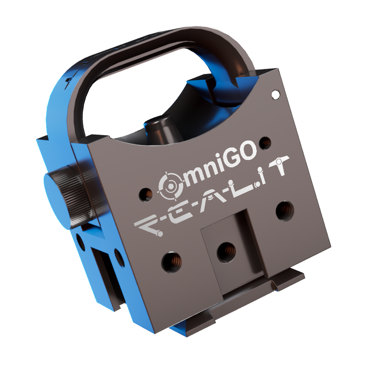
Every BLK2GO purchase from us comes complete with the OmniGO adapter at no extra charge. Mount your scanner to any standard survey pole or tripod in seconds — no tools, no guesswork. It's the accessory you didn't know you needed, included by default.
Learn More About OmniGO
The BLK2GO uses real-time LiDAR scanning and SLAM tracking for mobile mapping of 3D spaces.

The BLK2GO’s enclosed dual-axis LiDAR sensor captures data in three dimensions as you walk through a space.

Take high-resolution images while scanning with the BLK2GO Point & Shoot camera. These images are automatically geotagged in the point cloud at the exact position where they were taken.

While you walk, the IMU (Inertial Measurement Unit) senses your movement to calculate the BLK2GO’s change of position in 3D space.
Architects and other AEC professionals use the BLK2GO to document as-built conditions for the restoration and renovation of existing spaces. Capture massive buildings with speed, accuracy, and efficiency to create the foundation for BIM designs and CAD drawings.
Facility managers can use BLK2GO scans to make accurate and informed decisions about their properties. Detailed floorplans allow facility managers to understand and improve the layout of specific facilities and to better understand the precise location of assets in their key directories.
The BLK2GO can be used to map large and complex buildings like hospitals, offices, and college campuses with unprecedented speed. The accurate floorplans that can be built from BLK2GO data streamline the retrofit process.
In real estate, every square meter counts. Accurate floorplans generated with BLK2GO ensure that owners get what their property is worth, and buyers know exactly what they are paying for.
Engineers bring their problem-solving skills to a project. When designing with specific goals in mind, engineers require the right tools; with the BLK2GO, they can scan spaces and digitally analyze, design, and build the best solutions for the project at hand.

Tell us when suits you and one of our experts will reach out to set up a demo.
Trusted by companies across Canada and the United States.
“R-E-A-L.iT’s assistance in helping RH Borden to get the most out of reality capture technology for our business has helped us deliver exceptional results for our clients. The custom software script that R-E-A-L.iT’s team created for us is enabling us to get high-quality deliverables into the hands of our clients in record time.”

“R-E-A-L.iT has been our dedicated source for all Leica Geosystems products for some time and we couldn’t be happier than with the service we’ve received. Their team shows passionate product knowledge and a handle on the latest in the industry. Derek has always been quick, courteous and very helpful. We will continue to purchase and rent Leica Geosystems 3D laser scanners with R-E-A-L.iT.”

“We’ve really enjoyed working with R-E-A-L.iT — renting reality capture gear through your team has been a smooth, reliable experience that helps us stay agile and efficient on our projects. The equipment is top-notch, and your service makes it easy to focus on the work at hand.”

“Unlike with some sales experiences, Derek and his team have been constantly available to us both pre- and post-sale, partnering with TELUS in implementing complex and long-term applications of reality capture solutions to our business.”
Contact us now for more information or to get started on your reality capture journey.
