
Sensor Fusion
The BLK2GO uses real-time LiDAR scanning and SLAM tracking for mobile mapping of 3D spaces.
El BLK2GO de Leica Geosystems es la forma más rápida y sencilla de escanear cualquier espacio o estructura de gran tamaño. Mientras usted recorre su entorno, el BLK2GO recopila millones de puntos de datos, creando un gemelo digital de su entorno para crear planos de planta, modelos BIM y visualizaciones 3D precisos. El BLK2GO pone la captura de la realidad y el poder de las nubes de puntos al alcance de todos.
The BLK2GO boasts a suite of industry-leading, innovative features that make it the most impressive imaging scanner on the market. With the touch of a button, gather millions of measurements in minutes, with incredible accuracy and speed. With no need for a tripod or specialized training, laser scanning is no longer only the realm of professional surveyors.
With its simple one-button operation, anyone can use the BLK2GO straight out of the box. Connect to your mobile device in seconds, and start gathering an amazing amount of data as you walk through your site. In only minutes, you’ll have a usable set of millions of data points, enabling you to supercharge your workflow and create amazing deliverables for your clients.
Indoors or out, the BLK2GO is your go-to tool for gathering millions of measurements quickly and easily. After wirelessly connecting the BLK2GO to your mobile device, you can track your data capture live in one hand while you walk through your space. Importing your data into the software of your choice is simple, efficient, and fast with wireless or wired data transfer options.
When you purchase a BLK2GO, you’re immediately equipped to gather millions of measurements faster than ever before. With everything you need to get started packed right into the box, you can get your team working with this revolutionary technology in just minutes.
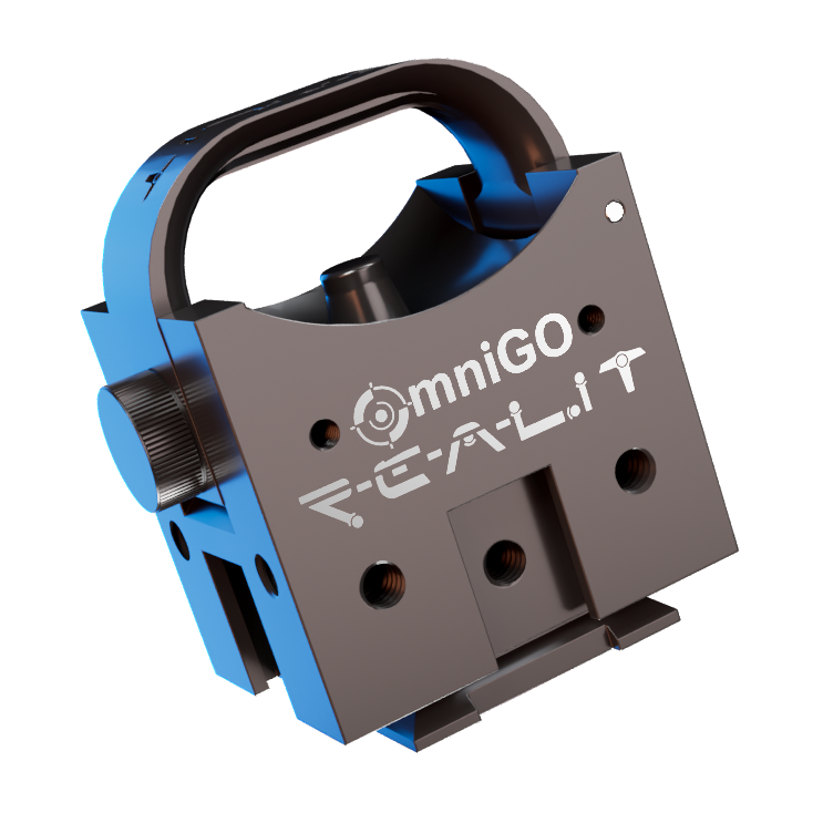
Every BLK2GO purchase from us comes complete with the OmniGO adapter at no extra charge. Mount your scanner to any standard survey pole or tripod in seconds — no tools, no guesswork. It's the accessory you didn't know you needed, included by default.
Learn More About OmniGO
The BLK2GO uses real-time LiDAR scanning and SLAM tracking for mobile mapping of 3D spaces.

The BLK2GO’s enclosed dual-axis LiDAR sensor captures data in three dimensions as you walk through a space.

Take high-resolution images while scanning with the BLK2GO Point & Shoot camera. These images are automatically geotagged in the point cloud at the exact position where they were taken.

While you walk, the IMU (Inertial Measurement Unit) senses your movement to calculate the BLK2GO’s change of position in 3D space.
Arquitectos y otros profesionales de la arquitectura, la ingeniería y la construcción (AEC) utilizan el BLK2GO para documentar las condiciones de obra para la restauración y renovación de espacios existentes. Capture edificios de gran tamaño con rapidez, precisión y eficiencia para sentar las bases de diseños BIM y dibujos CAD.
Los administradores de instalaciones pueden usar los escaneos BLK2GO para tomar decisiones precisas e informadas sobre sus propiedades. Los planos detallados permiten a los administradores de instalaciones comprender y mejorar la distribución de instalaciones específicas, así como comprender mejor la ubicación precisa de los activos en sus directorios clave.
El BLK2GO permite mapear edificios grandes y complejos, como hospitales, oficinas y campus universitarios, con una velocidad sin precedentes. Los precisos planos que se pueden generar a partir de los datos del BLK2GO agilizan el proceso de modernización.
En el sector inmobiliario, cada metro cuadrado cuenta. Los planos precisos generados con BLK2GO garantizan que los propietarios obtengan el valor de su propiedad y que los compradores sepan exactamente lo que están pagando.
Los ingenieros aportan sus habilidades de resolución de problemas a un proyecto. Al diseñar con objetivos específicos, necesitan las herramientas adecuadas; con el BLK2GO, pueden escanear espacios y analizar, diseñar y construir digitalmente las mejores soluciones para el proyecto en cuestión.

Dinos cuándo te viene bien y uno de nuestros expertos se pondrá en contacto para coordinar una demostración.
Con la confianza de empresas en todo Canadá y Estados Unidos.
“La asistencia de R-E-A-L.iT para ayudar a RH Borden a aprovechar al máximo la tecnología de captura de realidad para nuestro negocio nos ha ayudado a entregar resultados excepcionales a nuestros clientes. El script de software personalizado que el equipo de R-E-A-L.iT creó para nosotros nos permite entregar productos finales de alta calidad a nuestros clientes en tiempo récord.”
“R-E-A-L.iT ha sido nuestra fuente dedicada para todos los productos Leica Geosystems desde hace tiempo, y no podríamos estar más satisfechos con el servicio que hemos recibido. Su equipo demuestra un conocimiento apasionado de los productos y un buen dominio de las últimas novedades de la industria. Derek siempre ha sido rápido, cortés y muy servicial. Seguiremos comprando y alquilando escáneres láser 3D Leica Geosystems con R-E-A-L.iT.”

“Hemos disfrutado mucho trabajar con R-E-A-L.iT: alquilar equipos de captura de realidad a través de su equipo ha sido una experiencia fluida y confiable que nos ayuda a mantenernos ágiles y eficientes en nuestros proyectos. El equipo es de primera calidad, y su servicio facilita concentrarnos en el trabajo que tenemos por delante.”

“A diferencia de algunas experiencias de venta, Derek y su equipo han estado constantemente disponibles para nosotros tanto antes como después de la venta, colaborando con TELUS en la implementación de aplicaciones complejas y a largo plazo de soluciones de captura de realidad para nuestro negocio.”
Contact us now for more information or to get started on your reality capture journey.
