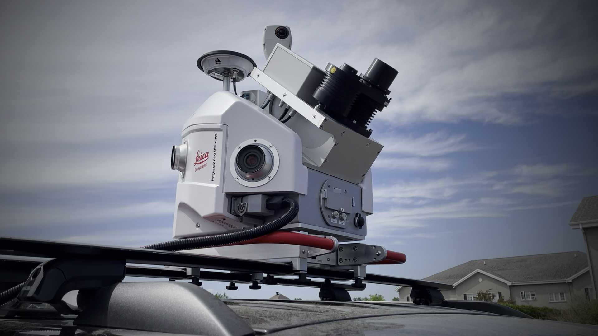
PEGASUS:TWO ULTIMATE
EFFICIENT REALITY CAPTURE EQUIPMENT
BE EFFICIENT
The Pegasus:Two Ultimate is a mobile mapping platform that delivers comprehensive, professional, reality capture data for creating digital cities.
The best in mobile mapping solutions
A smart city relies on the accurate digitisation of infrastructure. The Pegasus:Two Ultimate enables you to deliver the highest quality and quantity of data quickly, safely and easily.
Gather enormous amounts of data with record speed
Add hours to your workday. With advanced sensors that allow data capture in a variety of lighting conditions and at varying speeds, you can gather more data each day, with greater reliability than other mobile mapping systems on the market.
A flexible solution, with impeccably accurate results
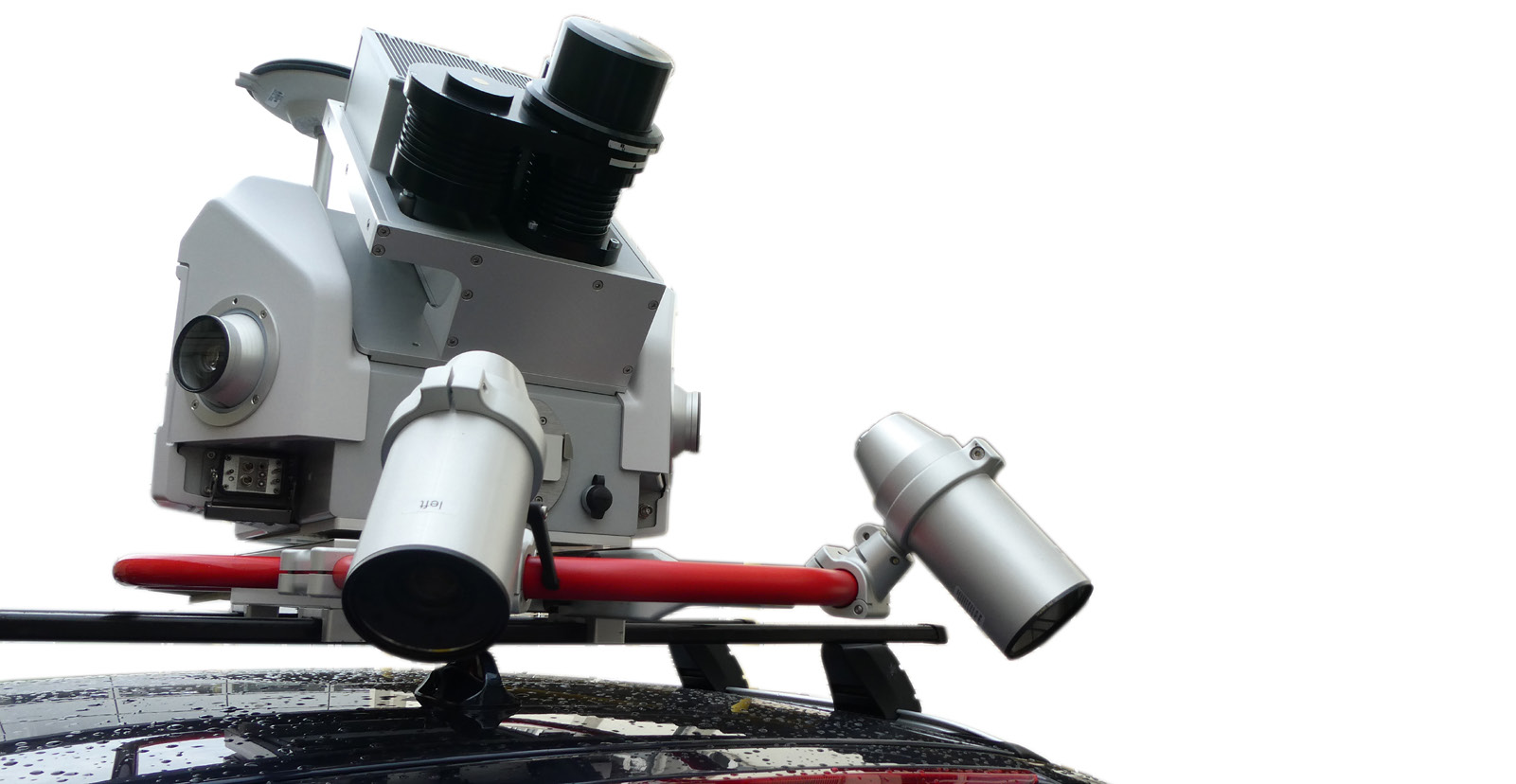
Dual-light sensors, 12 MP side-cameraas, 24 MP 360 degree imagery, and a telescopic pole make the Pegasus: Two Ultimate the top of the line mobile mapping solution. A removable solid-state hard disk with integrated USB 3.0 connection allows you to take your data with you easily and quickly. Additional ports allow the connection of thermal imaging equipment, sonar, ground-penetrating radar sensors, side pavement cameras, and more.
A complete and reliable system for moving cities into the future
Seamless 360 degree imagery calibrated to your point cloud can be capture from car, train, or boat. No matter your needs, the Pegasus Two:Ultimate can provide high quality digital reality capture solutions for all your smart city applications.
Serious solutions for significant needs
The Pegasus Two:Ultimate from Leica Geosystems is a comprehensive smart city digitisation tool that will bring you to the forefront of the industry. With a seamless integration between this serious hardware and our complete selection of software solutions, a futuristic smart city can be a present reality.
Meet the Tech.
Your Complete Mobile-Mapping Solution
The Pegasus:Two Ultimate is a complete, reliable, efficient, and trusted mobile mapping platform, equpping you to create digital cities visualizations in record time.
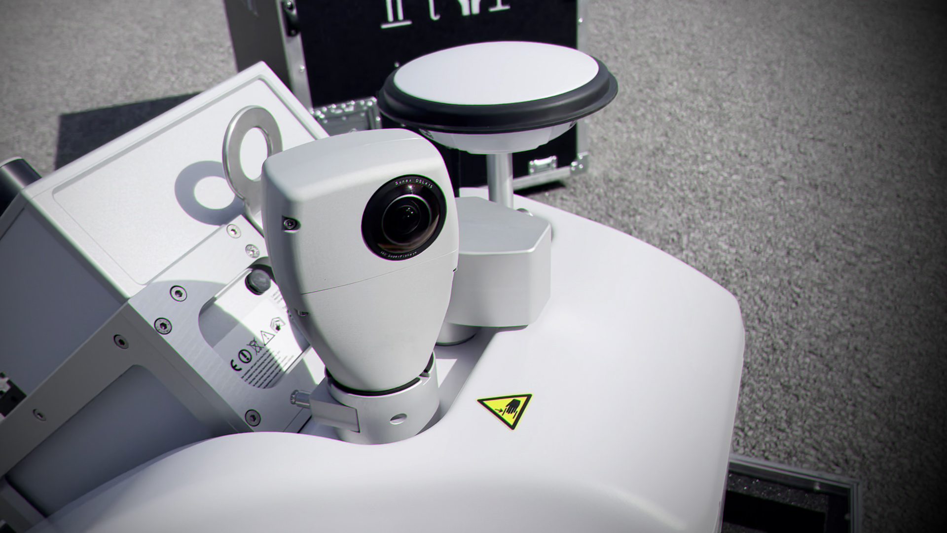
Back-to-Back Cameras
Two integrated back-to-back cameras create a 24 MP, 360 degree image calibrated to the LiDAR profiler.
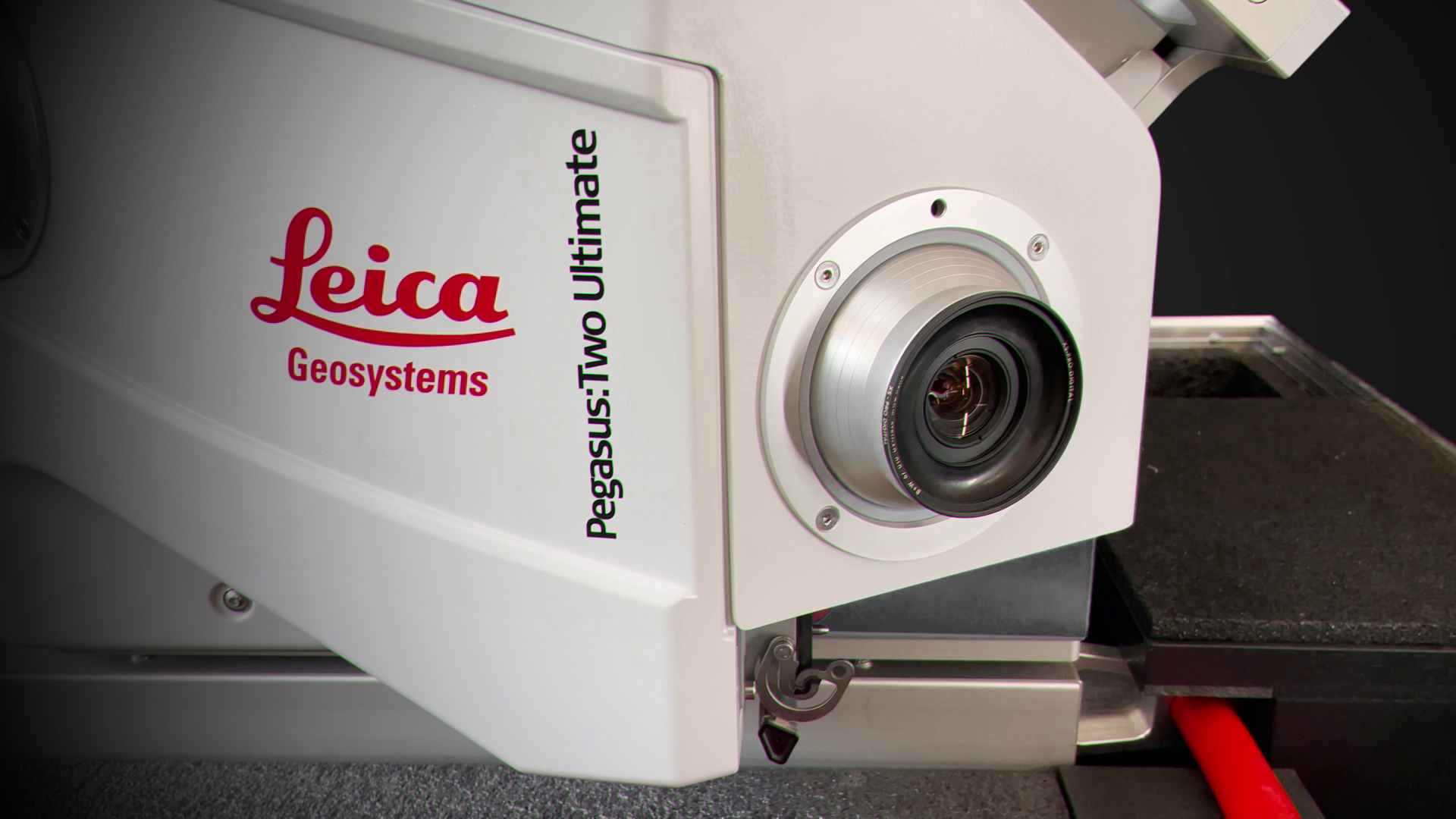
Supreme photogrammetry and image quality
Large sensor to pixel ratio and dual-light sensor enable to you to work within a greater range of lighting conditions, extending your working day.
Adjustable pavement camera
Wtih 12 mm lenses, the adjustable pavements cameras enable targeted imaging capture along a road or in a tunnel.
Apply your data.
Infrastructure Documentation
Modern cities require modern infrastructure solutions, and exisiting, as-built data is often non-existent. Collecting data around a large city is cumbersome, time-consuming, expensive, and dangerous. With the Pegasus:Two Ultimate, you can document your city's infrastucture through the simple act of driving. No more traffic interruptions or saftey risks -- just clean, clear data in almost no time at all.
Capture data in difficult terrain
Infrastructure in difficult terrain is notoriously hard to document. When you need survey-grade data about roadways or bridges in steep, mountainous, or otherwise complicated areas, the Pegasus:Two Ultiamte is the right tool for the job.

Long-distance infrastructure management.
When highways and railways are part of the equation, document all the data you need quicklu and easily by traveling your route with the Pegasus:Two Ultimate. No need to interrupt rail schedules or close highways -- you can get all you need without stopping the flow of traffic.
Specifications
DESIGN & PHYSICAL
Width: 650 mm (25.59 in.)
Height: 680 mm (26.77 in.)
Depth: 680 mm (26.77 in.)
WEIGHT
51 kg85.8 kg
MOUNTING
Rotational platform to mount on almost any vehicleOPERATION
CONTROL
Multi-core industrial PC, low power consumptionWIRELESS
Ethernet and wireless connections available. Service support available through remote connection.DATA STORAGE
Removable 1 TB HDD with USB3.0 interface, sync port for PPS/NMEA/DMI outputs.POWER
EXTERNAL
9 hrs (profiler version); 13 hrs (scanner version)SCANNING
DISTANCE MEASUREMENT
High-speed phase-based laser scanner, 1500nm wavelengthLASER CLASS
1 (according to EN60825-1 / ANSI Z136.1)FIELD OF VIEW
360 (HORIZONTAL)167 (VERTICAL)
RANGE
0.3 (MIN)119 (MAX)
SPEED
Up to 1,000,000 pts/secDENSITY
Based on capture speed and rotation speed of laser profilerIMAGING
CAMERA
2 dual fish-eye cameras, 24 MP panoramic camera system (2 x 12 MP)SPEED
ContinuousTHERMAL
Optional (external)ENVIRONMENTAL
OPERATING TEMPERATURE
-10 (MIN)45 (MAX)
STORAGE TEMPERATURE
-20 (MIN )50 (MAX)
IP RATING
IP54NAVIGATION SENSORS
GNSS
YesDATA PROCESSING
DATA TRANSFER
USB, ethernet and wireless connections available through the battery system. Service support available through remote interface.DESKTOP SOFTWARE
Pegasus Manager
Ready to learn more?
Our EXPERTS@R-E-A-L.iT are ready to help you with onboarding this new technology in your business. Whether you need to train your employees with this new hardware, or have questions about what software solutions to use in the office to get the most out of your data, we are ready to assist you at every step of the process. Check out our coaching plans here. Still have questions? Click the button below to start a conversation with one of our experts.
Contact Us.
-

-

-

-

Our
EXPERTS@R-E-A-L.iT
are ready to help you with onboarding this new technology in your business. Whether you need to train your employees with this new hardware, or have questions about what software solutions to use in the office to get the most out of your data, we are ready to assist you at every step of the process.
Still have questions? Click the button below to start a conversation with one of our experts.