PEGASUS TRK
EFFICIENT REALITY CAPTURE EQUIPMENT
AUTONOMOUS. INTELLIGENT. SIMPLIFIED.
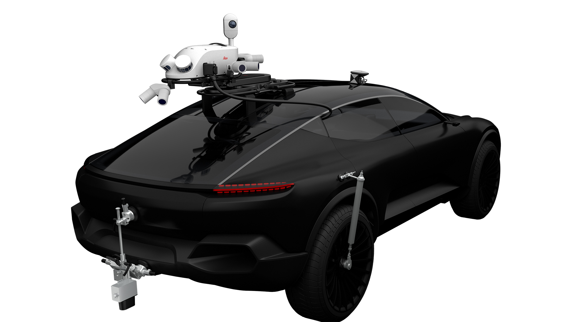
The Leica Pegasus TRK100 is an advanced mobile mapping solution that revolutionizes geospatial data collection. It combines high-resolution cameras, LiDAR scanners, and GNSS receivers to capture precise 3D imagery and point clouds. With real-time processing capabilities and intuitive software, it empowers professionals with accurate and actionable geospatial information for various applications.
MAP FURTHER, FASTER
The Leica Pegasus TRK100 is a versatile mobile mapping solution designed for efficient geospatial data collection. With its integrated sensor suite and real-time processing capabilities, it enables precise capture of 3D imagery, point clouds, and geospatial positioning data. It empowers professionals across industries with accurate and actionable geospatial information.
SMALL THINGS DONE IN A GREAT WAY
Presenting the Leica Pegasus TRK100, a game-changing mobile mapping solution. Equipped with cutting-edge sensors and real-time processing capabilities, it revolutionizes geospatial data collection. Capture high-resolution imagery, point clouds, and precise positioning data on the move. Experience the power of accurate mapping and unlock endless possibilities for informed decision-making.
THIS IS NOT AN ILLUSION
The Leica Pegasus TRK100 offers an unparalleled user experience with its intuitive design and ease of use. With its simple setup and automated data acquisition, mapping becomes effortless. Real-time quality control ensures accurate results, while the user-friendly software interface allows for seamless visualization, analysis, and reporting. Harness the power of mapping with ease.
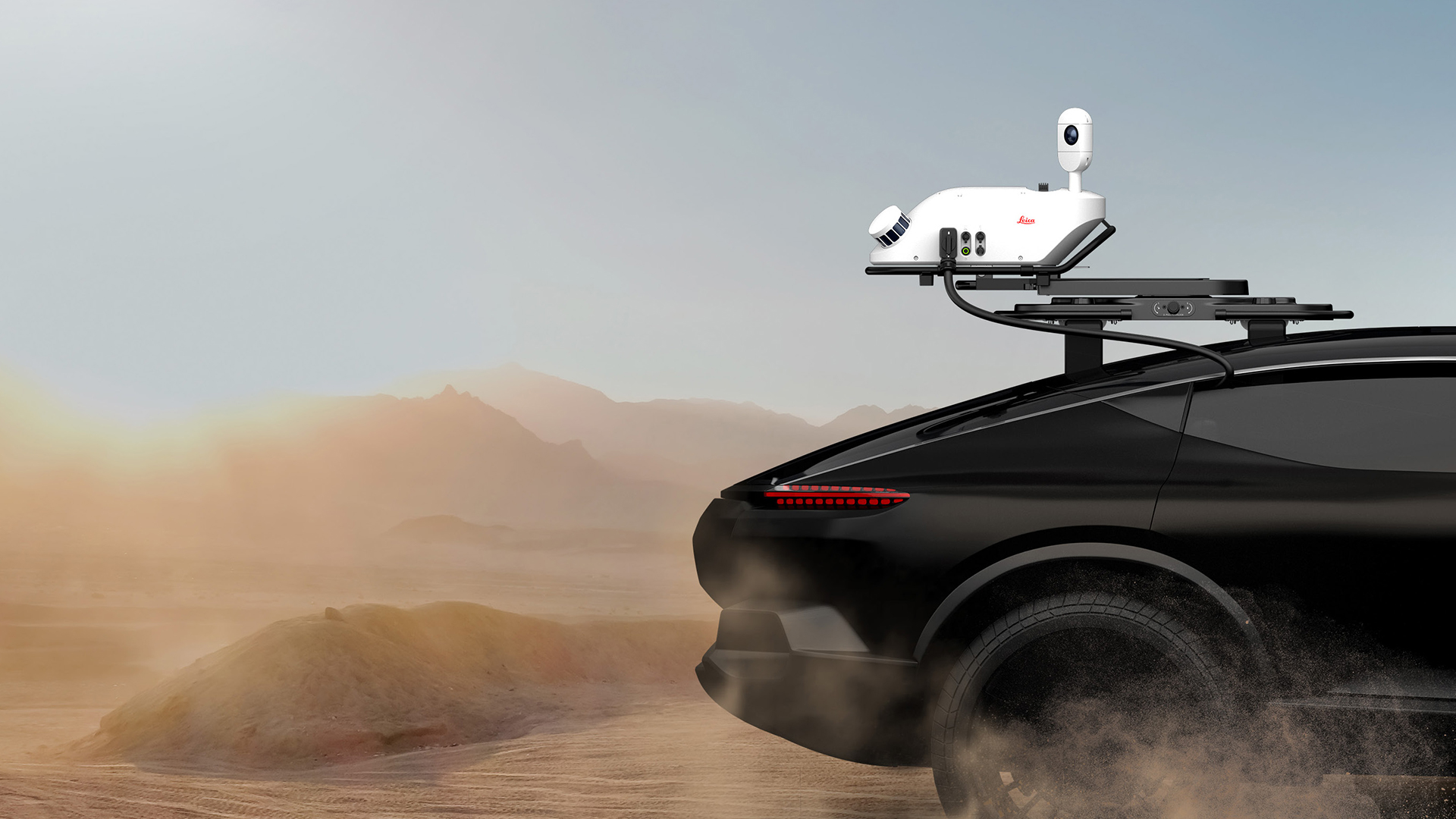
NEW ROUTES OPEN NEW DOORS
Proven durability takes mapping to new levels. Challenging environments won’t challenge your ability to map the assets you need, wherever the fork in the road takes you. The Leica Pegasus TRK100 is IP67 certified, fully dust tight and tolerates temporary immersion under water. This rugged system can withstand 4g shocks and conforms to ISO9022 and MIL-STD-810H norms. Anti-fog camera lenses, enables capture in fast changing environmental conditions.
THIS IS THE FUTURE OF MOBILE MAPPING
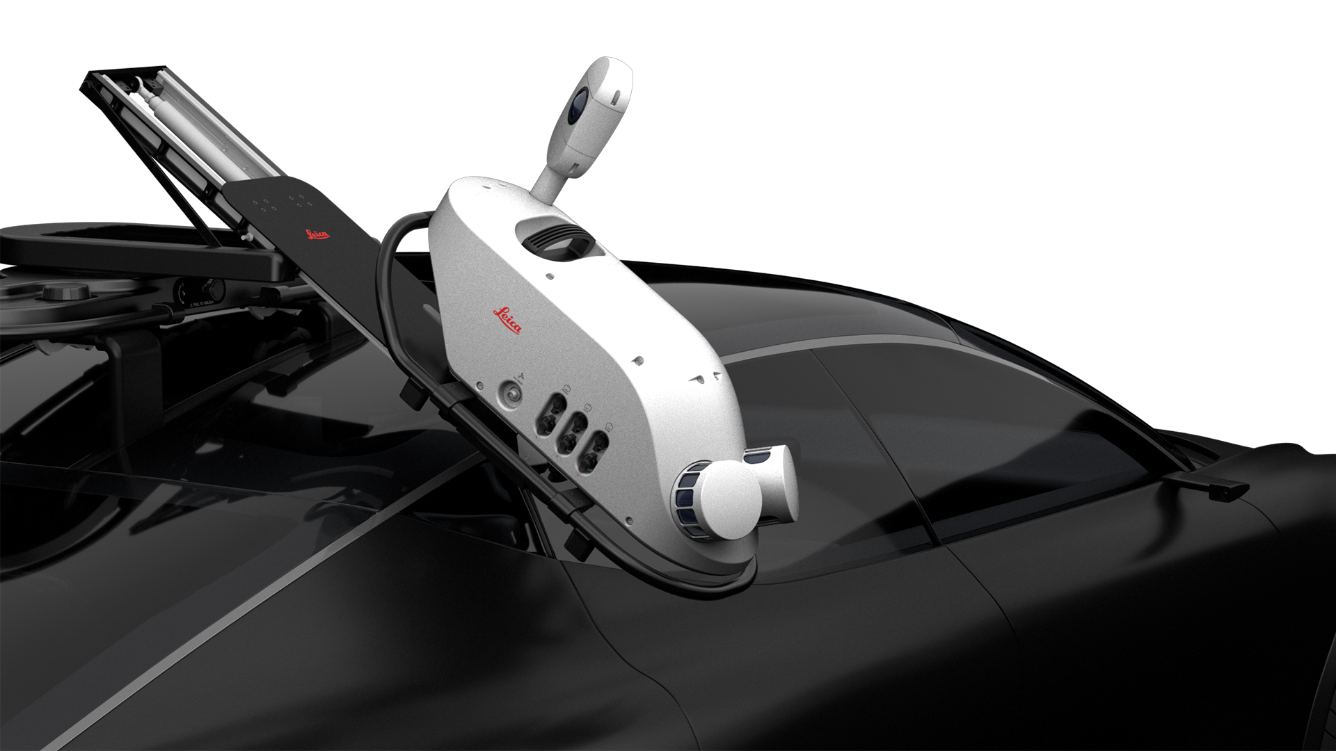
When purchasing a Leica Pegasus TRK100 mobile mapping solution, you can expect to find a comprehensive package. The box includes the TRK100 system itself, complete with its integrated sensor suite, software, and documentation. Additionally, you'll receive necessary cables, mounting accessories, and a user-friendly guide to get you started on your mapping journey.
Meet the Tech.
MatchPoint Technology
With the introduction of the unique MatchPoint technology, the Leica Pegasus TRK100 enhance and optimise clarity of points for improved accuracy of asset mapping.
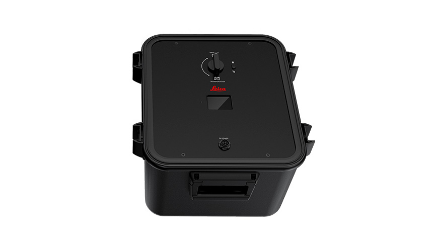
Power that lasts the day
Experience uninterrupted scanning and mapping with the Leica Pegasus TRK100 battery unit. Its remarkable 8-hour longevity empowers you to tackle extensive projects without any worry of power constraints, ensuring maximum efficiency and productivity in the field.
Designed to last
Embrace relentless exploration. With an IP67 rating, it operates seamlessly, remaining fully dust-tight, and even withstands temporary immersion under water. Now, you can confidently conquer any terrain and weather conditions, knowing your equipment is built to endure the toughest challenges.
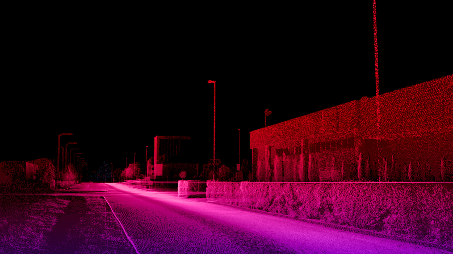
Incredible Millimeter Accuracy
The Leica Pegasus TRK100 can precisely measure and map the position and elevation of objects and features with incredible detail, ensuring reliable and highly accurate data for your mapping and surveying needs.RTK [X,Y], [Z]: 21mm, 13mm
Apply your data.
Bring images and data to life.
Best-in-class colour truth - brought to life as it is in reality. Pegasus TRK features a SmartFusion ‘butterfly’ camera system with up to 120MP integral view. Boosted with add- on front, side and rear pavement cameras, TRK is expandable with a click. The additional cameras multiply the resolution, creating data-rich imagery. Enhanced calibration delivers true colour imagery according to the CIEDE2000 colour-difference formula.
Built-in Privacy
Say goodbye to manual object blurring. People and vehicles are anonymised in real-time, protecting citizen privacy and ensuring GPDR compliance. Integrated with a real-time AI algorithm, the Pegasus TRK solution actively identifies and blurs complete objects directly in the imagery as the data is collected. All information is encrypted and won’t leave your Pegasus TRK system.

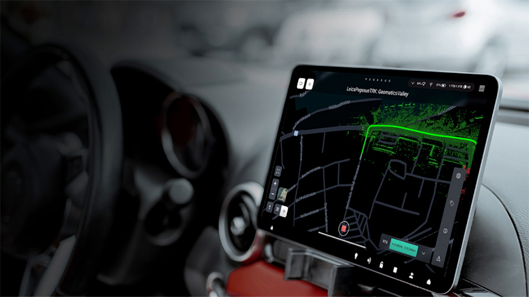
Plan. Capture. Deliver
Plan and execute projects with confidence. Spontaneous visual and audio feedback along the route makes data collection failure a thing of the past. Leica Pegasus FIELD predicts the time required for planned missions and storage and battery capacity needed to perform the job. Throughout the journey, image previews, accuracy estimations, and live system feedback instil absolute confidence in the data acquisition process.
Specifications
DESIGN & PHYSICAL
Width: 33 cm (13 inches)
Height: 49cm (19.3 inches)
Depth: 70 cm (27.6 inches)
WEIGHT
14 kg27 kg with battery
MOUNTING
Rotational-Fix carrier platform with secure click-mechanism for Pegasus TRK allowing to rotate the Sensor Unit by -30° / 0 ° /+30°. Dedicated Thule roofbars to be used.OPERATION
CONTROL
Ruggedised, IP54, industrial grade, multi-core PC with built-in machine learning chip; 5.0 inch colour and touch LCD displaying live battery health monitoring; Data pre-processing and AI based tasksDATA STORAGE
2 x 2TB or 2 x 3.8TB, real-time data stream to high performance, removable SSD`sPOWER
EXTERNAL
Vehicle independent; Hot-swappable, up to 3 x Li-Ion Pegasus battery units; Ruggedised, IP54, industrial grade, 2.4 inch colour LCD displaying real-time batteryhealth monitoring; 8h / battery unit; Transportation mode for ground and aircraft shipping; Fully compliant to dangerous goods UN 3480/3481SCANNING
DISTANCE MEASUREMENT
Mechanical DMI (Distance Measuring Instrument/ Odometer) Kit, IP67, containing mechanical DMI, wheel clamp, 5 m cable to connect the DMI to the PCU and inlet for mechanical DMI to fit into Core Accessory Box. Available for Pegasus TRK.LASER CLASS
Class 1, eye safeFIELD OF VIEW
360 ° (HORIZONTAL)360 ° (VERTICAL)
RANGE
0.4 m (MIN)100 m (MAX)
SPEED
20Hz per scannerIMAGING
CAMERA
120 Mpixel total (24 Mpixel panoramic camera, 48 Mpixel butterly side, 24 Mpixel pavement, 24 Mpixel front). Self-calibrating directional cameras. Real-time AI-driven image blurring (GDPR compliant). Color calibration according to CIEDE2000. Real-time automatic brightness control.SPEED
By distance at 8 fpsENVIRONMENTAL
OPERATING TEMPERATURE
-10 ° C (MIN)50 ° C (MAX)
STORAGE TEMPERATURE
-20 ° C (MIN )50 ° C (MAX)
IP RATING
IP67 during operation, fully dust tight and withstands temporary immersionunder waterNAVIGATION SENSORS
GNSS
GNSS 555 channel, multi-constellation, multi-frequency. Antenna fully integrated, with additional second antenna support.
DESIGN & PHYSICAL
Width: 33 cm (12.9 inches)
Height: 56 cm (22 inches)
Depth: 70 cm (27.6 inches)
WEIGHT
18 kg23 kg with battery
MOUNTING
Rotational-tilt mount, adjustable in horizontal postition -30°, 0°, +30°, tilitng up to 45° improving accesibility and ergonomics by reducing 36cm the mounting height.OPERATION
CONTROL
Pegasus FIELD - browser-based interface, accessible by Wi-FI or cable; Mission Planning, Project Management, autonomous data acquisition with routed navigation, real-time anonymisation, pre-processing and remote support.WIRELESS
Integrated WirelessDATA STORAGE
2x2TB or 2x3.8TB, real-time data stream to high performance, removable SSD'sPOWER
EXTERNAL
Hot-swappable, up to 3 x Li-Ion Pegasus battery units. 7h /battery unitSCANNING
LASER CLASS
Class 1, eye safeFIELD OF VIEW
360 ° (HORIZONTAL)360 ° (VERTICAL)
RANGE
1.5 m (MIN)Maximum range 490m/250m (50% reflectivity), 205m/130m (10% reflectivity) (MAX)
SPEED
500,000 pts/secDENSITY
Based on capture speedIMAGING
CAMERA
120 Mpixel total (24 Mpixel panoramic camera, 48 Mpixel butterly side, 24 Mpixel pavement, 24 Mpixel front). Self-calibrating directional cameras. Real-time AI-driven image blurring (DDPR compliant, data encrypted). Real-time automatic brightness control.SPEED
By distance at 8 fpsENVIRONMENTAL
OPERATING TEMPERATURE
-10 ° C (MIN)50 ° C (MAX)
STORAGE TEMPERATURE
-20 ° C (MIN )50 ° C (MAX)
IP RATING
IP67 during operation, fully dust tight and withstands temporary immersion under waterNAVIGATION SENSORS
GNSS
Leica AS11 GNSS antenna for faster initialisation by more accurate heading
DESIGN & PHYSICAL
Width: 46 cm (18.1 inches)
Height: 56 cm (22 inches)
Depth: 72 cm (28.3 inches)
WEIGHT
23 kg28 kg with battery
MOUNTING
Rotational-tilt mount, adjustable in horizontal postition -30°, 0°, +30°, tilitng up to 45° improving accesibility and ergonomics by reducing 36cm the mounting height.OPERATION
CONTROL
Pegasus FIELD - browser-based interface, accessible by Wi-FI or cable; Mission Planning, Project Management, autonomous data acquisition with routed navigation, real-time anonymisation, pre-processing and remote support.WIRELESS
Integrated WirelessDATA STORAGE
2x2TB or 2x3.8TB, real-time data stream to high performance, removable SSD'sPOWER
EXTERNAL
Hot-swappable, up to 3 x Li-Ion Pegasus battery units. 6h/battery unitSCANNING
LASER CLASS
Class 1, eye safeFIELD OF VIEW
360 ° (HORIZONTAL)360 ° (VERTICAL)
RANGE
1.5 m (MIN)Maximum range 490m/250m (50% reflectivity), 205m/130m (10% reflectivity) (MAX)
SPEED
1,000,000 pts/secDENSITY
Based on capture speedIMAGING
CAMERA
120 Mpixel total (24 Mpixel panoramic camera, 48 Mpixel butterly side, 24 Mpixel pavement, 24 Mpixel front). Self-calibrating directional cameras. Real-time AI-driven image blurring (DDPR compliant, data encrypted). Real-time automatic brightness control.SPEED
By distance at 8 fpsENVIRONMENTAL
OPERATING TEMPERATURE
-10 ° C (MIN)50 ° C (MAX)
STORAGE TEMPERATURE
-20 ° C (MIN )50 ° C (MAX)
IP RATING
IP67 during operation, fully dust tight and withstands temporary immersion under waterNAVIGATION SENSORS
GNSS
Leica AS11 GNSS antenna for faster initialisation by more accurate heading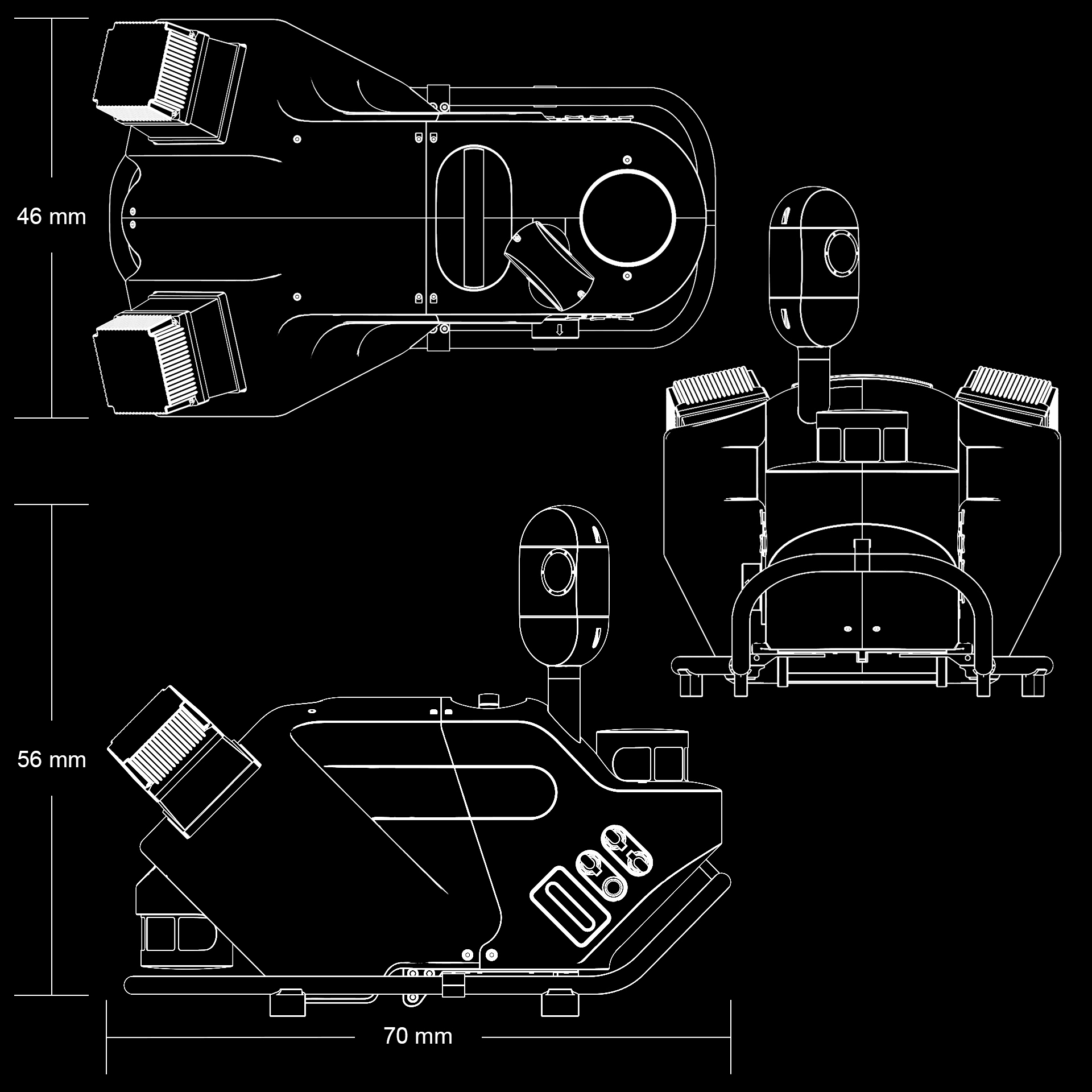
DESIGN & PHYSICAL
Width: 33 cm (12.9 inches)
Height: 56 cm (22 inches)
Depth: 70 cm (27.6 inches)
WEIGHT
21 kg26 kg with battery
MOUNTING
Rotational-tilt mount, adjustable in horizontal postition -30°, 0°, +30°, tilitng up to 45° improving accesibility and ergonomics by reducing 36cm the mounting height.OPERATION
CONTROL
Pegasus FIELD - browser-based interface, accessible by Wi-FI or cable; Mission Planning, Project Management, autonomous data acquisition with routed navigation, real-time anonymisation, pre-processing and remote support.WIRELESS
Integrated WirelessDATA STORAGE
2x2TB or 2x3.8TB, real-time data stream to high performance, removable SSD'sPOWER
EXTERNAL
Hot-swappable, up to 3 x Li-Ion Pegasus battery units. 7h /battery unitSCANNING
LASER CLASS
Class 1, eye safeFIELD OF VIEW
360 ° (HORIZONTAL)360 ° (VERTICAL)
RANGE
0.3 m (MIN)Maximum range 182m (10% reflectivity) (MAX)
SPEED
500,000 pts/secDENSITY
Based on capture speedIMAGING
CAMERA
120 Mpixel total (24 Mpixel panoramic camera, 48 Mpixel butterly side, 24 Mpixel pavement, 24 Mpixel front). Self-calibrating directional cameras. Real-time AI-driven image blurring (DDPR compliant, data encrypted). Real-time automatic brightness control.SPEED
By distance at 8 fpsENVIRONMENTAL
OPERATING TEMPERATURE
-10 ° C (MIN)50 ° C (MAX)
STORAGE TEMPERATURE
-20 ° C (MIN )50 ° C (MAX)
IP RATING
IP65 | IP66 with protection capNAVIGATION SENSORS
GNSS
Leica AS11 GNSS antenna for faster initialisation by more accurate heading
DESIGN & PHYSICAL
Width: 46 cm (18.1 inches)
Height: 56 cm (22 inches)
Depth: 72 cm (28.3 inches)
WEIGHT
29 kg34 kg with battery
MOUNTING
Rotational-tilt mount, adjustable in horizontal postition -30°, 0°, +30°, tilitng up to 45° improving accesibility and ergonomics by reducing 36cm the mounting height.OPERATION
CONTROL
Pegasus FIELD - browser-based interface, accessible by Wi-FI or cable; Mission Planning, Project Management, autonomous data acquisition with routed navigation, real-time anonymisation, pre-processing and remote support.WIRELESS
Integrated WirelessDATA STORAGE
2x2TB or 2x3.8TB, real-time data stream to high performance, removable SSD'sPOWER
EXTERNAL
Hot-swappable, up to 3 x Li-Ion Pegasus battery units. 7h /battery unitSCANNING
LASER CLASS
Class 1, eye safeFIELD OF VIEW
360 ° (HORIZONTAL)360 ° (VERTICAL)
RANGE
0.3 m (MIN)Maximum range 182m (10% reflectivity) (MAX)
SPEED
1,000,000 pts/secDENSITY
Based on capture speedIMAGING
CAMERA
120 Mpixel total (24 Mpixel panoramic camera, 48 Mpixel butterly side, 24 Mpixel pavement, 24 Mpixel front). Self-calibrating directional cameras. Real-time AI-driven image blurring (DDPR compliant, data encrypted). Real-time automatic brightness control.SPEED
By distance at 8 fpsENVIRONMENTAL
OPERATING TEMPERATURE
-10 ° C (MIN)50 ° C (MAX)
STORAGE TEMPERATURE
-20 ° C (MIN )50 ° C (MAX)
IP RATING
IP65 | IP66 with protection capNAVIGATION SENSORS
GNSS
Leica AS11 GNSS antenna for faster initialisation by more accurate heading
Ready to learn more?
Our EXPERTS@R-E-A-L.iT are ready to help you with onboarding this new technology in your business. Whether you need to train your employees with this new hardware, or have questions about what software solutions to use in the office to get the most out of your data, we are ready to assist you at every step of the process. Check out our coaching plans here. Still have questions? Click the button below to start a conversation with one of our experts.
Contact Us.
-

-

-

-

Our
EXPERTS@R-E-A-L.iT
are ready to help you with onboarding this new technology in your business. Whether you need to train your employees with this new hardware, or have questions about what software solutions to use in the office to get the most out of your data, we are ready to assist you at every step of the process.
Still have questions? Click the button below to start a conversation with one of our experts.